Mountains, Cliffs, and Caves: A Comprehensive Guide to Using Perlin Noise for Procedural Generation
- Feb 27, 2025
- 6 min read
Updated: Jan 28

Procedural generation is everywhere—you’ve probably encountered it without even realising. It’s what gives in-game worlds their rolling hills, jagged cliffs, and winding cave systems. And at the heart of it all is Perlin noise: a special kind of randomness that isn’t entirely random at all. It’s smooth where it needs to be, rough when we want it to be, and endlessly customizable.
But what exactly is procedural generation? In simple terms, it’s a method of creating natural-looking textures and objects using algorithms instead of manually designing every detail.
Take Minecraft as an example. Every time you load up a new world, you’re presented with an entirely unique landscape. These worlds aren’t designed by hand (think of the poor interns). Instead, they’re built using procedural generation. Unlike traditional, handcrafted environments, procedural generation lets us create massive, complex landscapes on the fly—often with just a few lines of code.
In this guide, we’ll break down how Perlin noise works, implement it from scratch, and tweak it to shape our terrain exactly the way we want. Keep reading till the end to see how we can take this idea even further to start designing underground cave systems.
All of the code for this project is available on GitHub. Feel free to try it out for yourself!
Let’s make some noise!

Believe it or not, this is the beginning of procedurally generated terrain. This is a graphical representation of noise – an array of randomly generated values between 0 and 1. There’s no apparent pattern to it, and right now it doesn’t look much like a terrain map at all. It’s random and discontinuous, which isn’t going to be much use for generating smooth terrain. What we really need is something more like this:

This is Perlin noise; it still looks pretty random and behaves unpredictably, but it has a smooth, continuous gradient that will make it much more useful for generating natural-looking terrain.
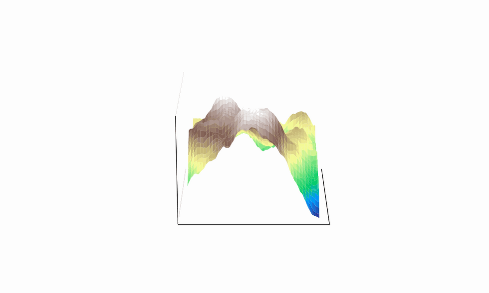
The colouring here simulates a top-down view of a topological map with snow-capped mountain peaks, green grasslands, and deep blue oceans. Perhaps it’s easier to visualise in 3 dimensions:

It’s not quite an epic mountain range yet, but it’s a step in the right direction. So before we try to fix it up into something more mountain-y, let’s explore how this smooth noise is created.
Thanks, Ken!
In his 1985 paper (linked below), Ken Perlin describes his noise generation algorithm. He outlines some use cases for generating random natural textures for computer graphics.
There are various different implementations of this algorithm, but the core ideas are as follows…
Instead of starting with an array of random numbers, we’ll begin with a coordinate grid of random vectors.

Perlin noise is generated on a per-pixel basis, so we’ll take each pixel in our output and map it onto the vector grid.
Here we introduce our first parameter, scale, which allows us to modify the way pixels are mapped to the vector grid. As we will see later, this affects the overall smoothness of the terrain.

Depending on the size of the terrain and the size of our desired output, we may need to expand or tile the grid to ensure it’s large enough to map all of our pixel coordinates.
Plotting one of the pixel coordinates on the vector grid, we can now work out a distance vector from the point to each of the bounding corners (shown in green below).

Taking the dot product of each gradient vector with its corresponding distance vector produces 4 numbers, one for each corner.
To calculate the final noise value for this pixel, we interpolate between the four corner values, first horizontally, then vertically. This ensures a point closer to one of the corner vectors is influenced by it more than the other vectors.
Once all noise values have been generated, the final step is to normalise the values to be in the range [0, 1]. This will give us the noise map as we saw before:

Adding some lumps and bumps
Changing the scale parameter alters the smoothness of the terrain.
A larger scale value results in high-frequency waves, making the result look quite jagged
A smaller scale value results in lower frequency waves that have a smoother appearance
Scale is the mapping of pixel values to the vector grid. When the scale is smaller, we map lots of values to each square of the grid, which gives us a smooth curve. When the scale is larger, we sample the vector grid over larger intervals, so there can be more dramatic changes in the noise values.


It’s all coming together now
We can employ a technique known as Fractal Brownian Motion to increase the detail and complexity of the terrain. The method involves combining multiple layers of Perlin noise with different frequencies and amplitudes to create a more natural-looking result.
The layers of noise are known as octaves.
Octaves
We can think about increasing the number of octaves by adding finer and finer levels of detail to our terrain. With one octave, we add broad shapes, with a second, we add slightly smaller features, but by the 6th or 8th octave, we are adding just small blemishes and details to the surface of the map.


We can also change the properties of the octaves and the way that we combine them using 2 more parameters: persistence and lacunarity.
Persistence
Persistence alters the contribution of each octave to the final result. We start with an amplitude of 1 for our first octave, and with each iteration, multiply the amplitude by our persistence scale factor.
For example, if we have persistence=0.5, we take 100% of the first octave, add the second one scaled down by 50%, then the next one scaled down to 25%, and so on. Each successive octave contributes less and less to the final result.
This coincides with the frequency of the octaves increasing so that we generate increasingly rough terrain, but it adds only small bumps to the surface rather than entirely new mountains.
Here we show an example of 2 octaves being combined with low versus high persistence.


The higher persistence model is impacted more by the higher frequency second octave, resulting in large jagged peaks sticking out of the ground.
By contrast, the lower persistence model has much smaller blemishes across the terrain as the impact of the second octave is smaller.
Lacunarity
The other parameter we can alter is lacunarity. This refers to the rate of change of scale between the octaves.
In the examples below, we use 4 octaves and a persistence of 0.25. The left model shows a lacunarity of 2.0, so the scale doubles with each octave, whereas the right model uses a value of 4.0, so the scale quadruples with each octave.


As we can see, the final results have the same overall shape, but the higher lacunarity model has a much higher frequency of the smaller features.
This parameter is more subtle than the others, but useful for altering the texture of the terrain.
I think I’m getting carried away…
Beyond Fractal Brownian Motion, we can employ further adaptations to customise our terrain map…
Moisture Levels and Biomes
We can use Perlin noise to represent things other than the height of the terrain. In this instance, we will use it to represent moisture levels in the environment. Combining the altitude and moisture levels, we can classify each coordinate into a different biome and then colour them accordingly.

Radial Dropoff
We can also apply functions to our noise maps to manipulate the terrain into different shapes.
In this example, we apply a quadratic function to our noise values that drops off as the coordinates get further from the centre of the mountain. This results in a tall island mountain sticking out of the sea.

Custom Functions
But we are not limited to a simple quadratic function. We can take a nice, complicated polynomial expression and apply it to our values.
The only thing to bear in mind is what the graph of the function looks like in the domain [0, 1]. We want to make sure that the function does not map our noise values to something outside of a reasonable range. This example below produces some interesting results, all while keeping the values within the range [0, 1].
We can then tailor this function to exaggerate and suppress different features of the landscape.
def f(x):
    return 7.105427e-15 + 0.7*x + 16.20*(x**2) - 69.76*(x**3) + 94.76*(x**4) - 41.07*(x**5) - 4.3


Cave Systems and Dungeons
We can also implement the Perlin noise algorithm in more than 2 dimensions, say for example… 3!
We can take a single octave of 3D noise, apply a threshold to the result and with a few tweaks and a bit of visualisation magic, the result is starting to look like an underground cave system:

With just a few clever applications of Perlin noise, we can create mountains, oceans, and even labyrinthine cave systems. By adjusting parameters like scale, persistence, and lacunarity, we gain fine control over the structure of our terrain, while layering multiple octaves adds depth and complexity.
And this is just the beginning. With further refinements—such as biome classification, moisture levels and the introduction of 3D models —we can push procedural generation even further. Whether you’re crafting a game world or experimenting with generative art, the power of noise is limited only by your imagination.
References and Further Reading
*All images are by the author unless stated otherwise.


Comments